Planning a working day at sea is not the same thing as checking whether tomorrow will be sunny.
For a professional underwater technical operator, weather and marine forecasts are part of the operational planning process: they influence when a job can start, how it should be organized, which equipment is required, how surface support must be arranged and, ultimately, whether contractual deadlines can realistically be met without compromising safety.
This distinction becomes particularly clear in the experience of Piero Giannetti and his son Giosuè, professional operators who have been using meteo@uniparthenope services since around 2010 and who were involved in the installation and management of floating docks supporting the 2026 sailing events in Sorrento.
The 2026 Tre Golfi Sailing Week concentrated several major international regattas in the Gulf of Naples and Sorrento area during May, including the ORC World Championship.
For Piero and Giosuè, however, the weather forecast was not about racing tactics.
It was about doing the work that makes events at sea possible in the first place.
Recreational diving and professional underwater work: similar environment, different planning
There is an important premise.
As Giosuè points out:
“At sea, above or below the surface, nothing should be left to chance, either for recreational or professional activities.”
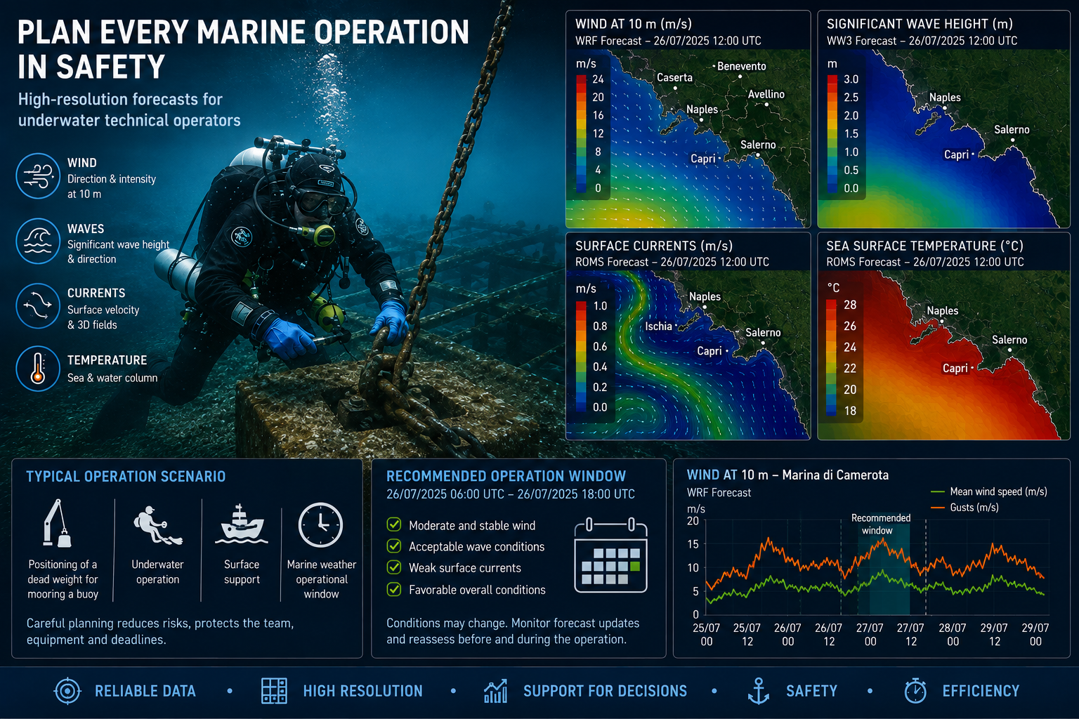
Weather and marine conditions matter enormously when planning a recreational scuba dive. Wave conditions affect entry and exit operations and the support vessel; currents can determine the feasibility and direction of a dive; temperature structure and potentially the depth of the thermocline can influence equipment choices and the experience underwater.
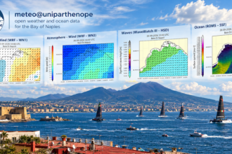
meteo@uniparthenope provides not only atmospheric forecasts but also wave and ocean-circulation products, making it possible to examine these factors together. Its operational chain integrates atmospheric forecasts from WRF, wave forecasts from WaveWatch III and coastal ocean predictions based on ROMS.
But there is a fundamental difference between recreational and professional operations.
A recreational dive can normally be postponed when conditions are unsuitable.
Professional work cannot always be treated in the same way.
As Giosuè explains:
“A recreational dive can always be postponed if the conditions are not acceptable. A professional service has to be completed within the time limits specified by the contract. This requires accurate planning, not simply alternative dates in case something goes wrong.”
That changes the role of the forecast.
The question is no longer simply:
“Can we go to sea tomorrow?”
It becomes:
“Within the contractual and operational window available to us, when are the conditions most favorable for carrying out this specific operation?”
That is a much more demanding problem.
First step: WRF and the wind
Piero describes their workflow as a sequence of analyses.
The first is atmospheric.
“First of all we look at the weather forecast supplied by the meteorological model. The website is very technical, maybe even too technical. We learned that the model is called WRF.”
For their type of activity, the most relevant atmospheric variables are generally straightforward:
wind direction and wind intensity.
Precipitation often has much less importance.
Piero summarizes it with the practical humor of someone who spends his working life around water:
“Except when we are operating near the mouth of a river, precipitation isn’t particularly interesting to us. Underwater it doesn’t rain and, for the people above… it’s only water.”
This does not mean that precipitation is irrelevant to every marine operation. Heavy rainfall can influence runoff, river discharge, turbidity and coastal circulation. But it illustrates an essential point about professional use of environmental models:
not every forecast variable has the same operational value for every job.
The meteo@uniparthenope WRF products provide high-resolution atmospheric forecasts, including detailed surface-wind fields. The current service describes WRF as its high-resolution weather forecasting component, integrated into the wider environmental prediction chain.
For an underwater technical operator, wind can immediately determine whether a planned operation remains realistic.
But the acceptable threshold depends on the work.
“It depends on what we have to do,” Piero explains. “Dredging is different from installing a buoy for a marine park.”
Different jobs mean different vessels, different equipment, different underwater tasks, different surface operations and therefore different sensitivity to environmental conditions.
If the work location is not geographically constrained, the solution may even be to change the sequence of operations and work elsewhere.
And, crucially, the forecast is consulted before a date is definitively assigned.
“If the place where we have to work isn’t fixed, we postpone that particular job until conditions are more favorable. Actually, already at this stage we use the forecast for planning before establishing the installation date.”
That is the first major difference between simply consulting a forecast and using a numerical forecast operationally.
Second step: waves
After the atmospheric forecast comes the wave model.
meteo@uniparthenope operates WaveWatch III as part of its marine forecasting chain. Its environmental forecast documentation describes wind-driven sea-wave products alongside WRF atmospheric forecasting and ROMS ocean circulation.
Piero’s assessment is particularly direct:
“Then we look at the wave model. It is very precise. Incredibly precise.”
For professional activities, significant wave height is only the beginning of the interpretation.
The same offshore wave condition can produce very different working conditions near a quay, a headland, a beach, a floating dock or a shallow coastal worksite.
And this is precisely where professional experience remains essential.
“The real limitation is that it doesn’t predict the type of wave in shallow water. But that’s nothing that experience can’t compensate for.”
Numerical modelling and field experience therefore do not compete with one another.
They complement each other.
A numerical model provides a spatially and temporally consistent picture of the atmosphere and sea. The operator then interprets that information using knowledge of the site: exposure, fetch, bathymetry, reflections from coastal structures, local currents and the response of the vessel and equipment being used.
Third step: currents — and potentially the thermocline
For underwater work, the atmosphere is only part of the problem.
The ocean itself moves.
This is where an integrated weather-marine forecasting system becomes substantially more useful than a conventional weather forecast.
meteo@uniparthenope uses the Regional Ocean Modeling System — ROMS for coastal ocean circulation. The system has been designed around nested domains to progressively resolve areas of particular interest, and ROMS’ vertical-coordinate approach is particularly suited to resolving structures including the thermocline and bottom boundary layer.
Currents can be important for both professional and recreational diving.
They affect the effort required by divers, the behavior of suspended equipment, deployment operations, the trajectory of floating objects and potentially the execution of tasks on the seabed.
Giosuè also raises an interesting possibility for recreational diving:
“It might be interesting to plan a recreational dive as a function of the thermocline as well.”
This illustrates another benefit of ocean modelling: moving from a simple description of the sea surface toward a three-dimensional description of the water column.
For an underwater operator, that distinction matters.
The Sorrento 2026 experience
Piero and Giosuè were involved in the setup of floating docks for the 2026 regattas in Sorrento.
The main international sailing programme occupied much of May, with the Tre Golfi Sailing Week running from May 5 to May 28 and the ORC World Championship in Sorrento from May 8 to 14.
Interestingly, Giosuè does not describe a dramatic episode in which a last-minute forecast “saved” the operation.
That is precisely the point.
Good planning is often invisible.
“The Sorrento regattas are concentrated in May and, with the meteorological conditions typical of that period, it is reasonably easy to schedule interventions sufficiently in advance, both for installation and, above all, dismantling.”
And:
“The meteo@uniparthenope forecasts are precise enough for us to avoid surprises.”
But forecast output is never considered in isolation.
“Above all, we compare different sources and plan taking our previous experience into account.”
This is also the correct professional approach to numerical prediction.
A model is not an oracle.
It is evidence.
Never use only one forecast
Piero and Giosuè repeatedly stress that they compare different sources.
Among these is the official Meteomar bulletin produced by the Italian Air Force, which remains an important official reference for Mediterranean marine weather.
The difference is scale.
Piero recalls:
“The official Meteomar bulletin must always be considered and followed as the primary official source. But it might talk about ‘Central Tyrrhenian Sea, Eastern Sector’, while what we need to know is what conditions will be like at Marina di Camerota.”
This is where high-resolution regional modelling becomes particularly valuable.
A forecast referring to a large marine sector answers one type of question.
A nested numerical model capable of resolving the meteorological and oceanographic structure of a specific stretch of the Campania coast answers another.
The two should not be confused and one does not replace the other.
For professional planning, they can be used together.
From 2010 to today
The Giannetti family’s relationship with meteo@uniparthenope goes back to before the service took its current public form.
Piero recalls meeting Raffaele Montella around 2010:
“We met Raffaele Montella — he wasn’t a professor yet — and he showed us the services in preview. He told us that they were the evolution of his PhD thesis and that the system had actually already been working unofficially for about ten years.”
At that time, according to Piero, geographically detailed numerical forecasts accessible to ordinary professional users were far less common.
“There was LaMMA Toscana, which is excellent, but naturally more focused on the northern Tyrrhenian Sea.”
The advantage they found in meteo@uniparthenope was localization.
“With meteo@uniparthenope, especially with short-term forecasts — 24 to 48 hours — we can understand much more precisely where and when something is expected to happen.”
That local emphasis remains central to the philosophy of the service. Today the CMMMA describes its operational infrastructure as producing daily updated high-resolution weather, ocean and environmental predictions, with nested modelling over Southern Italy, the Tyrrhenian Sea and coastal areas.
One forecast is useful. A sequence of forecasts is more informative.
Perhaps the most interesting part of the Giannettis’ method is that they do not simply open the forecast once.
They return to it.
Piero explains:
“We consult the products separately and then build a single overall picture during planning. We compare them with other sources and carry out several cycles of analysis and verification.”
This includes something experienced forecasters do almost instinctively: examining how the prediction for the same target time changes between successive model runs.
“By seeing how the forecast for a particular day changes from one day to the next, we manage to get an idea of the reliability of the prediction — which we know changes.”
This is an important observation.
A forecast that remains substantially consistent over several successive initialization cycles gives the operator a different level of confidence from one in which wind direction, timing, wave height or the arrival of a disturbance continue to shift.
In other words, professionals are interested not only in:
What does today’s model say about Thursday?
but also:
How stable has the prediction for Thursday been during the last few model cycles?
Piero even suggests this as a possible direction for the evolution of the service:
“Perhaps an improvement could be made precisely in this direction.”
A future operational product explicitly representing forecast stability, run-to-run variability or ensemble-derived uncertainty could translate something expert users already estimate manually into immediately readable information.
The real strength: an integrated atmosphere-wave-ocean system
For professional operations at and below the sea surface, the most distinctive aspect of meteo@uniparthenope is therefore not a single map.
It is the integration of several high-resolution numerical modelling chains:
- WRF for the atmosphere and, in particular for this type of activity, wind speed and direction;
- WaveWatch III for the sea state generated by wind;
- ROMS for coastal ocean circulation and three-dimensional marine dynamics;
- additional environmental and transport modelling products developed within the CMMMA ecosystem.
In the operational forecasting panorama of the eastern sector of the central and southern Tyrrhenian Sea, this combination makes meteo@uniparthenope particularly distinctive: atmosphere, waves and coastal ocean circulation are available within the same regional modelling ecosystem rather than being treated as unrelated services.
This integration is especially valuable for the Gulf of Naples, the Sorrento Peninsula, the Campania coast and the surrounding Tyrrhenian sectors, where coastline geometry, orography and local circulation can make the difference between a broad marine forecast and the environmental information required at an actual worksite. The CMMMA forecasting chain itself uses nested high-resolution domains over Southern Italy and the Tyrrhenian Sea.
For a professional underwater operator, the correct workflow is therefore not:
open a weather app → look at the icon → decide whether to work.
It is closer to:
define the operation → identify its environmental limits → analyze wind → analyze waves → analyze currents → compare sources → examine successive forecast cycles → incorporate local experience → define the operational window.
Models support decisions. Professionals make them.
There is a final point that deserves emphasis.
Numerical products from meteo@uniparthenope are automatically generated model outputs. The service itself explicitly states that their interpretation should be performed by experts and that they do not substitute official information or documentation.
Piero and Giosuè’s working method is an excellent example of what this means in practice.
They do not ask a model to make the decision for them.
They use WRF, WaveWatch III and ROMS to build situational awareness.
They compare forecasts.
They watch how those forecasts evolve.
They confront the models with official sources.
And finally they add something no numerical simulation contains:
years of experience working on and under that particular sea.
That may ultimately be the most appropriate way to use meteo@uniparthenope professionally.
Not as a weather app.
Not as a replacement for seamanship, professional expertise or official information.
But as a high-resolution environmental decision-support system capable of bringing together atmosphere, waves and ocean circulation at spatial and temporal scales that are genuinely useful when the question is not simply whether to go to sea —
but how to work safely, efficiently and on schedule once you get there.