For the 40th Velalonga, meteo@uniparthenope brings high-resolution weather, wave, open-data and GRIB services to the sailors of the Bay of Naples: from tactical wind layers to onboard navigation files ready for marine electronics.
On Sunday, June 21st, 2026, the Bay of Naples becomes once again a race field, a meeting place, and a celebration of seamanship. The Lega Navale Italiana – Sezione di Napoli presents the 40th Velalonga as a historic regatta and a “festa del mare di Napoli”, marking forty editions of sailing tradition in the Gulf. The programme includes the Over60 and Ladies’ Cup events on June 20, followed by the 40th Velalonga start at 11:00 local time on June 21, with prize-giving scheduled at 16:30 and the traditional social events afterward.
For sailors, coaches, race committees and spectators, this is exactly the kind of event for which meteo@uniparthenope was built: turning advanced numerical modelling into practical, accessible information over one of the most complex and fascinating coastal sailing areas in the Mediterranean.
High-resolution forecasting for a complex sailing arena
The Gulf of Naples is never just “one wind field.” The breeze interacts with the coastline, the islands, the Sorrento Peninsula, the urban heat island, and the slopes of Vesuvius. Small differences in timing and direction can shape starts, laylines, sail selection and race management.
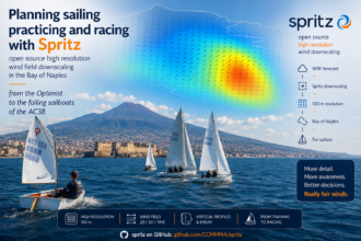
For many decades, the meteo@uniparthenope group has worked to provide unprecedentedly detailed weather and marine forecasts over the Bay of Naples, with open access to model products reaching local resolutions up to 1 km. This operational commitment is part of the wider mission of the University of Naples “Parthenope” Center for Monitoring and Modelling Marine and Atmospheric research and applications, which delivers daily updated high-resolution weather, ocean and pollution forecasts.
That same experience has already supported major international sporting events. meteo@uniparthenope has been officially active since 2011 and provided weather services for the America’s Cup World Series in Naples in 2012 and 2013, as well as the Universiade in 2019. During the 2012 and 2013 America’s Cup World Series events, the team delivered dedicated forecasts at 450 m resolution over the race field. Today, that legacy continues with new products and workflows ready to support the next generation of high-performance sailing, including AC38.
Forecast focus for Velalonga day
For Velalonga 2026, sailors can follow the dedicated Baia di Napoli forecast page, where products can be selected by date, time, model and output layer. The page exposes map and chart options, including open data access in JSON, CSV, OPeNDAP and WMS formats; all forecast times are referenced to UTC.
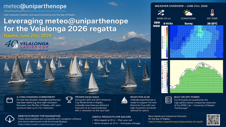
On June 21st, 2026, the WRF5 forecast for the Bay of Naples indicates a warm summer day, with air temperatures generally in the mid to upper 20s °C, roughly 24–32 °C through the 24-hour period. The wind at 10 m is expected to remain light to moderate, mostly from the southerly to south-westerly sector, with speeds generally below about 10 kn. Overall, conditions look suitable for sailing, with a gentle breeze and warm temperatures; crews should still monitor the latest hourly updates before and during the regatta.
The wave forecast feed for June 21st from WaveWatch III points to very calm sea-state conditions at the reference point: the hourly time series reports significant wave height about 0.2 m throughout the 24-hour period, with icons changing from glassy during the morning UTC hours to rippled from 12:00 UTC onward. After the early hours, wave direction is mostly from the southwest-to-west sector, with short periods generally around 2.5–4.6 seconds.
As always, model output should be interpreted together with direct observation, official race communications and prudent seamanship. The meteo@uniparthenope products are generated automatically using numerical weather prediction techniques and are provided as operational decision-support tools, with UTC used for all time references.
Two tactical products for sailors
For crews preparing sail plans and race strategy, two wind products are especially useful on the Bay of Naples forecast page.
Wind speed at 10 meters helps translate the model field into immediate sail-selection decisions. In the operational colour scale, blue shades suggest light genoas or jibs, green shades indicate medium genoas or jibs, yellow shades point toward jibs, and red shades call for caution or sheltering decisions. This layer is the first screen to keep open before the start and during the pre-race observation window.
Wind variation at 10 meters adds the tactical dimension. The isolines show where the wind has rotated clockwise or counterclockwise since the previous hour, while warm and cold shades indicate where wind speed has increased or decreased. This is particularly valuable in the Gulf, where a shift line, a thermal-breeze acceleration, or a weakening sector can be the difference between sailing lifted or pinned.
Together, these two products help crews move from a simple “what is the wind now?” question to a more useful racing question: where is the wind changing, and how fast is that change moving across the Bay?
Get the actual readings from the weather stations network
The Sensor Network is the data portal for the observational weather-station network managed by meteo@uniparthenope. It provides a stations map, browse/download functions depending on user permissions, and public dashboards for several stations across the Naples and Campania area, including Centro Direzionale, Gaiola, Città della Scienza, Marina di Stabia, Castel Volturno, Via Acton, Villa Doria D’Angri, and Sant’Agata dei Due Golfi. These real-time observations complement the numerical forecasts, helping sailors, researchers, and citizens compare model output with measured local conditions.
Open data, GRIB files and onboard use
meteo@uniparthenope is not only a website. It is an open data infrastructure. Forecast data are available through API, OPeNDAP, HTTP and Signal K; the HTTP APIs are freely accessible without authentication or key registration.
For sailors using navigation software or multifunction marine displays, the GRIB service is especially important. GRIB files are designed for compact storage and exchange of meteorological forecast fields, and meteo@uniparthenope updates its GRIB data multiple times per day as model runs complete.
The GRIB directory already lists the main operational files for the European domain, the Italian peninsula and surrounding seas, and the southern Italy/Campania domain, with files available in .grb, .gz and .zip formats. These files are ready to be used in navigation software and marine-electronics workflows, making the same forecast chain available both on shore and on board.
Signal K integration further extends this ecosystem: meteo@uniparthenope provides live AIS data for the Bay of Naples and weather-station data as a Signal K meteo context, enabling compatible marine electronics to display live weather information directly on nautical charts.
The HPC infrastructure behind the forecast
The precision of these products is made possible by dedicated scientific computing. The High-Performance Scientific Computing Laboratory – HPSC Lab of the Department of Science and Technology of the University of Naples “Parthenope” designs, implements and manages the computational workflow that routinely produces the forecast data, together with the related high-performance computing infrastructure and instrument network.
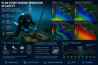
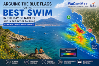
This infrastructure is not limited to sailing forecasts. The same applied-HPC ecosystem supports services for environmental protection, public health and territorial risk. MytilEx, for example, is an operational HPC-based system for modelling potentially toxic substances in water and in farmed bivalve molluscs along the Campania coast, supporting planning and maintenance activities for mussel-farming operators. The Apps portfolio also includes SmokeTracer, described as a high-performance distributed-computing web system for modelling fire-dispersion events.
In this sense, Velalonga 2026 is more than a regatta supported by a weather forecast. It is a public demonstration of how open science, high-performance computing and local environmental knowledge can serve citizens, sailors, institutions and the sea.
Fair winds to Velalonga 2026
For the crews of the 40th Velalonga, the recommendation is simple: check the Baia di Napoli forecast page, follow the 10 m wind speed and wind variation layers, download the GRIB files for onboard planning, and compare the model guidance with real-time observation before and during the race.
meteo@uniparthenope will continue to make high-resolution weather and marine forecasts openly available for the Bay of Naples, supporting everyday navigation, scientific research, public services and major sailing events — from Velalonga to the next America’s Cup horizon.