How weather-model maps can help sailors and boaters recognize conditions favorable to sudden afternoon thunderstorms
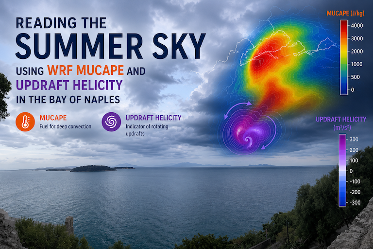
Summer thunderstorms in the Bay of Naples can develop rapidly after a calm and sunny morning. MUCAPE and Updraft Helicity forecasts produced by the WRF model help identify atmospheric conditions favourable to strong and organised convection, providing useful guidance for sailors, boaters and weather enthusiasts.
During a hot Mediterranean summer afternoon, the Bay of Naples may appear calm and inviting. The sea can be almost flat, visibility excellent, and the wind pleasantly moderate. Yet, within a relatively short time, dark clouds may develop over the surrounding hills, thunder may be heard in the distance, and a violent gust can suddenly sweep across the water.
These apparently improvised changes are not entirely unpredictable. Numerical weather models can identify atmospheric conditions that favour the development of thunderstorms several hours before the first cumulonimbus cloud becomes visible.
Among the products provided by meteo@uniparthenope, two indicators are especially useful for understanding the potential severity and organisation of summer convection:
- MUCAPE — Most Unstable Convective Available Potential Energy
- Updraft Helicity
Used together—and always considered alongside wind, precipitation, clouds, radar observations and official warnings—these parameters can help sailors and boaters develop a more informed picture of the afternoon weather risk.
This is particularly relevant for the Bay of Naples, whose international visibility is rapidly increasing as Naples prepares to host the Louis Vuitton 38th America’s Cup in 2027, with the Match scheduled to begin on 10 July. The competition area will lie just off the Naples waterfront, beneath the distinctive outline of Mount Vesuvius.
Why thunderstorms can develop after a calm, hot morning
Summer thunderstorms require more than high temperature alone. Three broad ingredients are normally needed:
- Moisture, usually concentrated in the lower atmosphere;
- Instability, meaning that a lifted parcel of air can become warmer and lighter than the air surrounding it;
- A lifting mechanism, capable of starting the parcel’s upward movement.
The intense heating of the land during the day can strongly increase instability. At the same time, evaporation from the Mediterranean supplies moisture to the lower atmosphere. Local circulations—including sea breezes, slope winds and convergence between winds arriving from different directions—may then provide the initial upward push.
Around Naples, the geometry of the coastline and the presence of Vesuvius, the Campanian Apennines and the hills surrounding the urban area make these interactions particularly complex. Summer sea-breeze circulations are a characteristic feature of the coastal atmosphere around Naples and may produce intricate local transport and convergence patterns.
When warm, moist air is lifted and encounters sufficiently cold air aloft, it may continue rising without further assistance. A small cumulus cloud can then grow rapidly into a deep cumulonimbus cloud.
From the sea, this transformation can seem sudden. In reality, the atmosphere may have been accumulating convective energy for several hours.
What the WRF model contributes
The Weather Research and Forecasting model, commonly known as WRF, is a numerical atmospheric model used internationally for both operational forecasting and research. It simulates the evolution of the atmosphere by solving equations describing motion, temperature, pressure, moisture, clouds and other physical processes. WRF is designed for applications ranging from broad regional weather systems to fine-scale atmospheric phenomena.
The WRF products published by meteo@uniparthenope provide geographically detailed forecasts for the Bay of Naples and the surrounding region. The portal allows users to select the forecast date, model product, atmospheric variable and time interval, and to inspect both maps and vertical atmospheric profiles.
These products should not be interpreted as photographs of the future. They represent a physically consistent model scenario based on the available initial conditions. Small errors in temperature, humidity, wind or the location of a convergence line can affect the predicted position and timing of an individual thunderstorm.
The maps are therefore most useful for identifying areas and periods of elevated potential, rather than predicting that a storm will pass over an exact coordinate at an exact minute.
MUCAPE: measuring the atmosphere’s convective fuel
CAPE stands for Convective Available Potential Energy. It measures the amount of energy that could become available to accelerate a rising air parcel. It is expressed in joules per kilogram, written as J/kg.
A useful everyday analogy is fuel in a tank. A large quantity of fuel makes powerful acceleration possible, but the presence of fuel does not mean that an engine has started. In the same way, high CAPE indicates that strong convective updrafts are physically possible, but it does not guarantee that a thunderstorm will form.
MUCAPE, or Most Unstable CAPE, is calculated using the most buoyant air parcel found within a lower layer of the atmosphere. It is intended to identify the parcel with the greatest potential to rise freely once it reaches its level of free convection.
Higher CAPE values are generally associated with a greater potential updraft speed and, consequently, with clouds capable of growing more rapidly and reaching greater vertical development.
For a sailor, MUCAPE helps answer the question:
If a thunderstorm starts, how much atmospheric energy could it potentially use?
A cautious interpretation of MUCAPE
Indicative ranges can help non-specialists read a map, although they must never be treated as universal warning thresholds:
- Below about 500 J/kg: generally limited instability;
- Approximately 500–1,000 J/kg: some convective development may be possible;
- Approximately 1,000–2,500 J/kg: moderate to strong instability;
- Above about 2,500 J/kg: very substantial instability, potentially supporting vigorous thunderstorms when the other ingredients are present.
These ranges are only broad guidance. Their significance changes with season, atmospheric structure, humidity, wind shear and the forcing mechanism. Even relatively modest CAPE can support thunderstorms when lifting is strong, while very high MUCAPE may remain unused when a stable layer—sometimes called a cap—prevents air parcels from rising.
MUCAPE should therefore be interpreted as potential energy, not as the probability of rain and not as a direct measurement of storm severity.
Why MUCAPE can increase during a summer afternoon
On a sunny day, the land surrounding the Bay of Naples normally warms faster than the sea. Air above the land becomes warmer and more buoyant, while cooler marine air begins moving inland as a sea breeze.
Where these air masses meet, convergence can occur: air arriving horizontally from different directions is forced upward. Additional lifting can occur where the sea breeze interacts with slopes and mountains.
As the afternoon progresses, the lower atmosphere may therefore become both warmer and locally more humid. MUCAPE can rise, especially over inland and elevated areas. Storms may initially form over the Apennines or around other topographic features and subsequently move toward the coast or generate outflow winds that reach the bay.
This explains why looking only at the sky directly above a boat can be misleading. The most important cloud may initially be developing tens of kilometres away.
Updraft Helicity: identifying organised rotating updrafts
MUCAPE describes the energy available to convection. Updraft Helicity, usually abbreviated as UH, describes a different property: the degree to which a modelled strong updraft is associated with vertical rotation.
In convection-permitting numerical models, UH is commonly calculated by vertically integrating the product of upward velocity and vertical vorticity through a selected layer of the atmosphere. In practical terms, it highlights places where the model simulates both strong rising motion and rotation within that rising column.
For sailors, Updraft Helicity helps answer a second question:
If convection develops, does the model suggest a strongly organised and rotating updraft?
A persistent UH signal can indicate that a simulated storm is more organised than an ordinary short-lived summer shower. Organised convection may survive longer and can be associated with stronger downdrafts, hail, intense rainfall, frequent lightning or damaging wind gusts.
However, Updraft Helicity must be interpreted with considerable caution.
A UH maximum is not a tornado forecast. It is also not a direct observation of atmospheric rotation. It is a model-derived diagnostic whose position and intensity depend on the model resolution, physical configuration, forecast lead time and simulated storm track.
The absence of a strong UH signal does not make a thunderstorm harmless. Non-rotating storms can still produce dangerous lightning, hail, torrential rain and violent straight-line winds.
Reading MUCAPE and Updraft Helicity together
The two fields become particularly informative when considered as complementary layers.
High MUCAPE but weak or absent Updraft Helicity
This configuration suggests that the atmosphere contains substantial convective energy, but the model is not clearly simulating persistent rotating updrafts.
Possible outcomes include:
- isolated pulse thunderstorms;
- rapidly growing but relatively short-lived cells;
- intense local rain;
- lightning;
- small or moderate hail;
- sudden downbursts and gust fronts.
For recreational navigation, this scenario can still be dangerous. A short-lived storm may produce a powerful wind burst even when it lacks organised rotation.
Moderate MUCAPE with a coherent Updraft Helicity track
This may indicate that wind shear and storm organisation are compensating for a less extreme amount of instability. The model may be simulating a storm with a longer life cycle and a more persistent path.
In this case, attention should be paid not only to the maximum UH value, but also to whether the signal:
- persists through several forecast times;
- follows a coherent trajectory;
- appears in successive model runs;
- overlaps areas of forecast precipitation or strong vertical motion.
High MUCAPE and persistent Updraft Helicity
When a broad reservoir of instability coincides with a coherent UH signal, the model scenario deserves particular attention. It suggests that strong convective energy and storm organisation may occur together.
For marine users, the primary concern is not limited to rotation. Such an environment may support:
- severe and abrupt wind gusts;
- hail;
- frequent cloud-to-ground lightning;
- intense rainfall and sharply reduced visibility;
- rapidly changing wind direction;
- rough, confused and locally steep waves;
- strong outflow boundaries travelling well beyond the rain shaft.
The correct interpretation is not “a severe storm will certainly occur here,” but rather:
The forecast atmosphere may support a more organised and potentially hazardous thunderstorm if convection is initiated.
The special danger of thunderstorm outflows at sea
One of the most underestimated thunderstorm hazards for boaters is the outflow boundary, or gust front.
Inside a thunderstorm, precipitation cools the air through evaporation and melting. This colder, denser air descends and spreads horizontally after reaching the surface. The resulting outflow may travel far from the visible rain core.
A boat can therefore encounter a sudden increase in wind speed before the rain arrives—or even when the storm itself remains over land.
Typical signs include:
- a darkening line beneath the cloud base;
- rapidly advancing low clouds;
- an abrupt fall in temperature;
- a sudden change in wind direction;
- a visible roughening of the sea surface;
- distant thunder becoming progressively louder.
On a sailing boat, the transition from a light summer breeze to a severe gust can happen too quickly to reduce sail safely after the wind has already arrived. The prudent decision must therefore be made from the forecast context and the storm’s evolution, not only from the conditions currently experienced on deck.
How to use the meteo@uniparthenope portal
To examine the convective environment over the Bay of Naples:
- Open the Golfo di Napoli forecast page.
- Select the WRF product.
- Choose MUCAPE from the available outputs.
- Move through the forecast hours, concentrating on the period from late morning to evening.
- Observe whether high values remain inland, expand toward the coast or extend across the bay.
- Select Updraft Helicity, where available, and examine the same sequence of forecast times.
- Compare the two products with forecast precipitation, wind, cloud cover and atmospheric profiles.
- Revisit the maps when a newer model run becomes available.
The example MUCAPE page for the Golfo di Napoli provides controls for the forecast time, product, output, displayed hours and aggregation step. It also provides access to maps, charts, vertical profiles and open-data services.
Pay attention to UTC
All times displayed by meteo@uniparthenope are referenced to Coordinated Universal Time, or UTC.
During Italian summer time, local civil time is normally two hours ahead of UTC. Therefore:
- 12:00 UTC corresponds to 14:00 local summer time;
- 15:00 UTC corresponds to 17:00 local summer time;
- 18:00 UTC corresponds to 20:00 local summer time.
This conversion is important when evaluating afternoon thunderstorm development.
Look for trends, not isolated coloured pixels
Weather-model maps contain considerable spatial detail, but not every small maximum should be interpreted literally.
A more reliable approach is to ask:
- Is the MUCAPE area growing as the afternoon approaches?
- Is it moving toward the coast?
- Does it appear in more than one forecast hour?
- Does the Updraft Helicity signal persist or appear only briefly?
- Do successive model runs show a similar pattern?
- Are precipitation, convergence and wind changes forecast in the same area?
- Is the possible storm moving toward the intended sailing route?
Consistency is generally more informative than a single intense grid-cell value.
The exact position of an afternoon storm may be displaced from the model prediction. Nevertheless, a repeated signal over the wider Campania region may still indicate that the Bay of Naples could be affected by lightning, outflow winds or rapidly changing sea conditions.
A practical routine for sailors and boaters
Before leaving harbour on a hot and potentially unstable day, a recreational marine user should combine several levels of information.
The evening before
Examine the general forecast and determine whether significant instability is expected. A broad area of elevated MUCAPE indicates that the following day may require closer monitoring.
On the morning of departure
Check the most recent WRF run. Compare MUCAPE with wind, precipitation and cloud forecasts. Determine whether Updraft Helicity signals are present during the intended navigation period.
During the day
Monitor the visible sky, official warnings, lightning information, radar and updated forecasts. Watch the inland skyline carefully, particularly toward elevated terrain.
Before the expected convective period
Consider shortening the route, remaining close to a safe harbour or returning earlier than originally planned. Thunderstorm avoidance is far safer than attempting to manage the storm after its outflow reaches the boat.
What these maps cannot tell you
Neither MUCAPE nor Updraft Helicity should be used alone to decide whether navigation is safe.
They cannot provide complete certainty about:
- the precise location of the first convective cell;
- the exact time of storm initiation;
- the route of an individual thunderstorm;
- the strength of every surface gust;
- the occurrence of lightning at a particular position;
- local conditions inside a harbour or near a headland.
Model resolution also matters. A simulated storm is an approximation of a physical process whose real structure may be smaller, larger, faster or differently located.
For this reason, model products must be combined with official forecasts and warnings issued by the responsible authorities, as well as with real-time observations and sound seamanship.
Understanding the sky of the future America’s Cup venue
The Bay of Naples is becoming one of the most closely watched sailing venues in the world. The 38th America’s Cup will bring extraordinary attention to its wind, waves, coastline and complex local meteorology.
Yet the same atmospheric processes that will challenge professional teams also affect fishing boats, sailing schools, yacht clubs, ferries, kayaks and recreational craft.
MUCAPE provides an estimate of the convective energy available in the atmosphere. Updraft Helicity indicates where the WRF model is simulating strong, potentially rotating and organised updrafts. Read together, they offer an accessible way to understand why a peaceful Mediterranean afternoon can evolve into a hazardous convective situation.
The essential lesson is simple:
High instability is the fuel, lifting can ignite it, and wind shear can organise the resulting storm.
Learning to recognise these ingredients does not replace professional forecasting. It does, however, help marine users ask better questions, interpret the changing sky and make more cautious decisions before the first thunder is heard.
The maps and derived products published by meteo@uniparthenope are generated automatically using numerical weather-prediction techniques. They are provided as model guidance and do not replace official forecasts, warnings, notices to mariners or decisions by the competent authorities. Navigation decisions remain the responsibility of the vessel’s skipper.