![]()
Weather Forecast for July 10, 2019
ENG VERSION
Current Conditions: the Campania Region is affected by warm air masses, which precede a low-pressure system coming from western Mediterranean basins. Therefore, in the next hours a worsening in weather conditions is expected, associated to a decrease in air temperature.
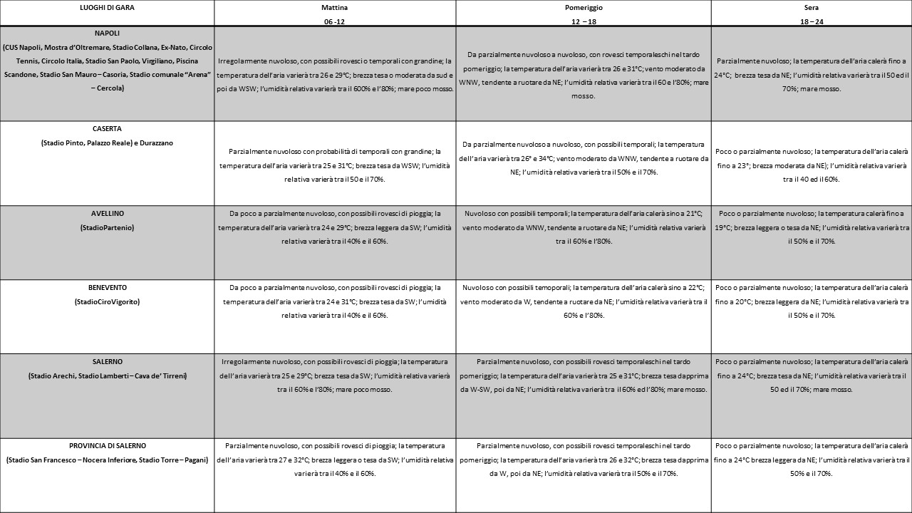
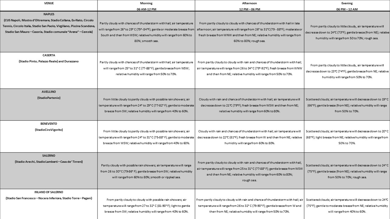
Weather Bulletin for July 10, 2019: in morning hours, partly cloudy conditions are expected, with possible isolated showers or thunderstorms. The highest chances of rainfall are attended in Naples district and Caserta Province. In the afternoon hours, showers and thunderstorms (associated to hailfall) will affect the inland sectors (Benevento and Avellino) and the plain of Caserta and, later, Naples district and Salerno Gulf. An improvement of weather conditions is expected in the evening hours.
In morning hours and in early afternoon, hot weather will occur in the entire area of interest: air temperature will reach peaks of 32-33°C (90–91°F) in the Provinces of Caserta and Benevento and in the inland of Salerno (Nocera-Pagani-Cava de’ Tirreni). During the afternoon, a gradual cooling will occur, starting from Benevento and Avellino, where air-temperature will drop around 20-22°C.
Winds will blow initially from south or southeast, with an average speed ranging from 10 to 25 km/h (6-15 mph); from late morning, they will turn from western and will increase in speed both in coastal and inland areas. In the afternoon, a further turning from northern is expected, with gusts up to 60-70 km/h (37-43 mph) on thunderstorm events.
Relative humidity percentage will range from 40 to 65% in morning hours, and then it will increase up to 80% in the inland sectors (Benevento and Avellino). Smooth to rough sea is expected.
Special Warnings: It should be highlighted the chances of heavy thunderstorm (especially in the afternoon hours), associated to hailfall, lightning activity and wind gusts.
Moreover, in the area of Caserta and Naples and in the inland of Salerno, the combination between heat and relative humidity will increase the likelihood of heat disorders with prolonged exposure or strenuous activity to the level “Extreme Caution”. The latter means that sunstroke, muscle cramps and/or heat exhaustion are possible with prolonged exposure and/or physical activity.
Table forecast for competitions and training venues
---------------------------------------------------------------------------------------------------------------------------------------------------------------------------------------------------------------------
ITA VERSION
Situazione attuale: il territorio campano è alle prese con masse d’aria calda provenienti dall’entroterra nord-africano, le quali precedono l’arrivo di una perturbazione atmosferica di origine atlantica. Quest’ultima sarà causa, nelle prossime ore, di un peggioramento delle condizioni atmosferiche, nonché di una flessione delle temperature.
Previsioni meteorologiche per il 10 Luglio 2019: in mattinata si prevedono condizioni di cielo irregolarmente nuvoloso, con possibili locali fenomeni, anche a sfondo temporalesco, più probabili sulle Province di Napoli e Caserta. Nelle ore pomeridiane nubi e piogge, a prevalente carattere di rovescio o temporale, interesseranno dapprima il beneventano, l’avellinese e il casertano, per poi estendersi anche alla Provincia di Napoli e al Golfo di Salerno. Nel corso della serata è previsto un progressivo miglioramento.
In mattinata e nelle prime ore del pomeriggio, le temperature saranno generalmente alte su tutti i siti di interesse. I picchi più significativi (32-33°C) si registreranno nel casertano, nel beneventano e nell’agro-nocerino-sarnese. Nel corso del pomeriggio, è prevista una diminuzione della colonnina di mercurio, ad iniziare dalle città di Benevento ed Avellino, ove intorno alle 18:00 il termometro scenderà sino a 20-22°C.
I venti, inizialmente, spireranno da sud o da sud-est, con intensità media variabile fra 10 e 25 km/h. Successivamente, gli stessi si disporranno da occidente e subiranno un rinforzo sia sulla fascia costiera sia nelle aree interne. Nel corso del pomeriggio è attesa una rotazione del campo di vento dai quadranti settentrionali, ad iniziare dai settori interni; in occasione delle manifestazioni temporalesche, sono previste raffiche sino a 60-70 km/h.
Il tasso di umidità relativa, nelle prime ore del mattino, oscillerà fra il 40 ed il 65%. Nelle ore pomeridiane, lo stesso subirà un incremento nelle aree interne, ove si registreranno valori sino all’80%.
Il moto ondoso si presenterà poco mosso o mosso.
Segnalazioni per condizioni meteorologiche avverse: si segnala la possibilità di manifestazioni temporalesche di forte intensità, accompagnate da grandine, intensa attività elettrica e forti colpi di vento (specie nelle ore pomeridiane).
È opportuno segnalare, inoltre, che nella prima parte della giornata la combinazione tra elevate temperature e tasso di umidità relativa inasprirà gli effetti della calura diurna. In caso di prolungata esposizione e di intensa attività fisica, saranno possibili colpi di calore e crampi muscolari.
Condizioni meteo per i campi di gara e di allenamento